| Main |
About EIG |
Services | Methodology | Equipment | Aerial Photography | Reports | Contact Us | Site Map |
METHODOLOGY
| For approximately the last fifty
years, this type of work has been conducted from aerial film positive
duplicates, called “diapositives”. These are used, instead of paper
prints, because the film has a much greater ability to retain the fine
details and gray tones present in the original negatives, from which
they were made. In a typical operation, the diapositive films are placed
on a light table, and a Zoom Stereoscope is brought over them for study. |
|
The Zoom Stereoscope
looks like a standard lab stereo microscope, except that it has
“rhomboids” underneath, which allow one eye to see the left photo, and
the other eye to see the right photo. In this fashion, the human brain
puts together the stereo view of the terrain. This stereo view is a
very important capability of the analysis procedure. It allows the
Interpreter to visualize the terrain and features 3-dimensionally.
Sometimes, one of the two photos may be degraded for some reason. When
this comes up, the human brain automatically puts more emphasis on the
better photo, while still preserving the stereo view provided by the
poorer quality photo. |
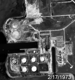
 Typical aerial film stereogram of an industrial site for historical analysis.
|
| Once the historical aerial photos
have been identified, produced by the agency holding the negatives, and
delivered, the real work of the Photo Interpreter can begin. Ideally,
this is done chronologically, that is, starting from the oldest photos
and moving forward through time, although this is not always possible.
The work itself is painstaking and, some would say, tedious. It is the
process of looking at the aerial images, recognizing ground objects,
describing them and deducing their significance. This information needs
to be captured in notes, which will then be reported informally over the
phone, or more commonly edited into a formal report. | |
| Many aids are available during this process. For example, “Photo Interpretation Keys” can be used to help recognize common features such as outdoor industrial equipment. This is done because the PI Key provides labeled ground photos, air photos, diagrams and descriptions for various kinds of equipment or buildings, or whatever. It is also the usual case to have a detailed layout plan for an industrial site while analyzing its activities. Historical ground photos may also be available. Ideally, these have been provided to the Photo Interpreter early, so that he or she can study them and become acquainted with the site while waiting the weeks for the film duplicates (or digital scan files) to be located, reproduced, and delivered. |
 A zoomed view into a particular industrial site. This is the facility overview. |
| However, the market
for historical aerial photography has been changing dramatically: FILM
reproductions are becoming harder and harder to obtain because of the
demise of the photographic wet lab. Instead, many agencies are providing
only digital scans of the original negatives. If the scanning was done
adequately, this is not a problem. However, to save money, much of this
scanning has been done too crudely, so that the details of an industrial
plant, fifty or seventy-five years ago, have been lost. In some cases,
the agencies have even destroyed the original films after scanning them,
to save money regarding storage costs. This represents a huge
historical loss! |
|
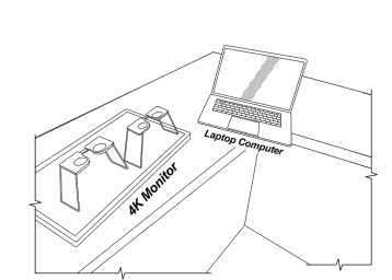
| Because of this change in the industry, increasingly, an alternative method for stereo observation, has been onscreen viewing using a Retina Display and a standard 2x Pocket Stereoscope. This methodology was initially used because of the decreasing availability of FILM duplications. However, after some experimentation and application, the new approach can be seen to provide many benefits over standard viewing with aerial film on a light table, observed through a stereo microscope. However, since some aerial photos are available as positive films, and others, as digital scans only, the analyst must be prepared to work in either medium. |  Setup
for digital stereo analysis of scanned aerial films. The 4K Monitor
lies flat on the worktable. The use of two folding, pocket stereoscopes
makes comparison between one year and another immediate instead of
delayed after further setup.
|
| The process of actually using the
aerial photography for analysis starts with cutting out the site
vicinity from each of the available stereo exposures. This might be done
physically on the film reproductions, or digitally, if scan files were
delivered by the source agency or company. In the optimum case, the
target area will appear on three consecutive exposures, leading to a
“stereo-triplet” like the one shown below. This will then be studied in
detail, in stereo, for the purpose of writing the analysis results. During the process, it is usual to compare the various years of photography, back and forth, in order to identify what changes are occurring through time at the site. So, if hard copy film is being studied, the stereograms from different years will be slid under the Zoom Stereoscope one after another to compare the various dates. However, if good scan imagery is available, then two, or three, or more stereograms can be read up to the external monitor and studied, simply by shifting the small, pocket stereoscope from one stereogram to the other. In modern times, this is the preferable way to work because it also allows pre-processing and optimizing of the imagery on the computer at the same time. In the example below, we see four different years of aerial coverage displayed side by side for the military facility centered in each stereogram. |
|
 |
The
monitor display setup for the easy tracking of changes through four
years of aerial coverage. On a 21-inch 4K monitor, this procedure works
very well for zooming in to part of the site to report detailed changes.
The zooming and positioning is primarily done in the computer software,
then the pocket stereoscope adds 2X and STEREO to it. |
| This more modern procedure can also be
nicely used for oblique photos. The stereo-triplet below shows some drone imagery of an airfield
under construction. Under stereo magnification, the details of the
ground activities are abundantly clear. This is the goal of such
historical analysis work. |
|
|
The
digital stereo technique also works very well for oblique photographs
or fieldwork photos on the ground. Here, we see obliques of
an airfield construction project which was monitored bi-weekly
using a drone.
|
 |